San Juans and Gulf Islands – 2011 South Coast BC
October 7th, 2011 | by Marilyn | Published in Ship's Log
In my mind, the San Juan and Gulf island groups are similar, though the San Juans are in the US and the Gulf Islands are in Canada. The main similarity is that they are both groups of developed islands, where you can easily find services and there are frequently houses along the shorelines. The Gulf islands are more relaxed than the San Juans – and cover a larger area – but the scenery and geology are similar. Because of our quest to get further north, we did not spend much time in either of these areas. But we did enjoy a few anchorages.
– On Stuart Island in the US, we visited Reid harbor twice this summer (about 2 months apart, first time on an earlier trip). Both times, there was the incessant pounding of a industrial jackhammer destroying the peace. Don’t anchor mid harbor or you will listen to the racket from early morning to late evening. The second time, we anchored at the head of the bay, and it was a distant rumble rather than a noise that could not be ignored. Is there a rock quarry there?? Or is some extremely rich person carving a house out of the rock? We couldn’t see it, just heard it.
– When entering Canada, we used our CanPass to clear customs by telephone and then reported to the RVYC outpost station in Long Harbour on Salt Spring Island as agreed during the phone clearance. The CanPass rep told us to look for a yellow “Customs” sign when we arrived at the outpost. When we got to the RVYC dock, there was no such thing, and no one at the dock knew anything about it. I used the very weak cell signal to call CanPass again and they said that since I was there at the appointed time but no customs officer was there, I was free to go on. I don’t think we’ll try that again. But it was nice to anchor in Long Harbour overnight because I suspect it was more relaxed than being in nearby Ganges Harbour.
– We went to Wallace Island twice, once on the way north and again on the way south. Both times we stayed in Princess Cove, which was very nice with useful stern tie rings on shore. We enjoyed a hike in the forest, though Van was stung by a wasp. Before anchoring the first time, we had a peek at Connor Cove, which seems to be much more coveted as there were 3 boats behind me lined up waiting to enter the narrow entry – indeed one squeezed through with me so he could beat me to the anchorage. I would much rather be in Princess Cove (assuming there is no strong northwesterly) where there is ample room without fighting over it. Connor Cove is cramped, too popular and the entry has a high risk of running aground. It seems like the most “popular” B.C. anchorages have dodgy entries due to shallow fairways with reefs and then once inside the anchorages have ample reefs and rocks lurking, waiting for your keel to pass by. I get the feeling that some boaters like the thrill of dangerous coves surrounding them. I like being tucked away, but…
– Another such extremely popular spot is Pirates Cove, De Courcy Island, which we visited on our way home. The fairway is shallow (about 1 fathom) and narrow (maybe 20 meters wide). You approach with a white painted mark on the beach lined up with the X on a tree to make sure you’ve cleared the reef before you turn 90 degrees to the left to navigate the narrow fairway. We entered with a brisk NW wind, and I was glad it was high tide! Once inside, the anchorage was OK though not great with the NW wind (no surprise since it opens to the North). We stern tied with our bow to the oncoming waves (meaning the wind would blow us onto shore if the anchor dragged, which is not the best arrangement). In the night when the tide was lower, we learned how far the reef on our port side extended into the “open water” (yikes!). The walk on the island was OK but the trees were small and the undergrowth non-existent. It’s not an old forest. So I don’t think we’ll be fighting our way to get back into Pirates Cove to join the summer crowds. (There was only 1 other boat there in early October when we visited.)
– We took Porlier Pass to exit the Gulf Islands, and Gabriola passage to return. The guidebooks warn about fierce eddies and boils in both those fast flowing passes during floods and ebbs, but we navigated both at slack water and had no problems.
– We spent our most crowded night of the entire trip at Silva Bay, Gabriola island. We dropped anchor amongst many other boats, lining up our anchor chain in the direction all the boats were facing. Then the wind shifted, and we all faced another way. It made me realize that people’s anchors could be anywhere – not necessarily in front of their bow. The wind came up at night, and Van got up about 3AM to sit an anchor watch for fear we’d run into another boat if our anchor dragged, or someone else’s did. Nothing bad happened, and he said he enjoyed staying up until dawn. The other odd thing that happened that night is that we heard these bizarre noises from our berth. It sounded like little boats zipping through the channel at incredibly high speed. Or maybe fighter jets taking off in the distance. Just weird vibrations coming through the hull. Lots of times, sounds below deck being are very different when you go out on deck, so it can be quite deceiving. Van eventually figured it out. It was the topping lift (which is the line the holds up the end of the boom when the main sail is not raised). It had gotten very tight when we hauled in the main sheet to secure the boom, and the wind was making the topping lift line vibrate like a guitar string. Depending on the wind speed, the vibration was transmitted to the mast, and at times the entire rig. Harmonics are really interesting science. We experience them all the time on the boat, because of the tension in the lines that hold the rig and sails. In this case, easing the tension on the topping lift made the ‘distance fighter jets’ and ‘zippy speed boats” disappear, and I could go back to sleep again.
– We stayed on the north side of Jones Island in the San Juans on the penultimate night of our journey. I’ve always wanted to stay there, but it’s a very popular park and the mooring buoys are always taken in the summer. (The guides books don’t recommend anchoring in the cove because of the strong currents, so getting a buoy is very desirable.) Even in early October with bad weather, three of the four buoys were taken. We spent a bouncy night swinging on the buoy, and I wondered why it is so popular with its wide opening to the North. Then we left the anchorage and immediately encountered 25 knot SE winds, gusting to 35 knots, and I better appreciated how sheltered we had been from the strong SE winds. We doubled reefed the main, and partially furled the jib and flew off on a close haul. I think this was the biggest winds we ever sailed in – though not the roughest water. I’m happy to say that both us and Rainshadow did well, compliments of the rig tuning that was required to properly balance our new sails. I could handle the helm despite the big winds. We reached 7+ knots at times – fast! We spent about 4.5 hours that afternoon making our way through Harney Channel and down to Hunter Bay on South Lopez, a distance of about 23 nautical miles (about 26.5 miles). I realized, though, that even that we seemed to be moving at an incredible speed through the water, with spray intermittently coming over the bow – it was all very exciting – my brother can still run a marathon faster than we can sail the same distance.
Next area – Strait of Georgia
-
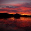
- Stuart Island has rewarded us several times with gorgeous sunsets
-
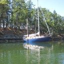
- Many of the coves are steep-to, making it possible to get your boat very close to shore. This BC park provided rings on shore making it simple to attach a stern line.
-
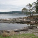
- A typical view from a beach in the Gulf islands. There is a lot of sculptured sandstone lining the shores.
-
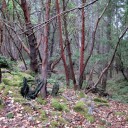
- The forest had lovely Madrona trees. The firs wer small, second growth.
-
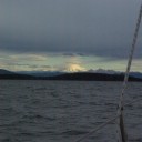
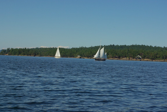
- This was our view as we sailed in the 25 knot winds through the San Juans.