Cruising the South Coast of British Columbia – Late Summer 2011
October 7th, 2011 | by Marilyn | Published in Ship's Log
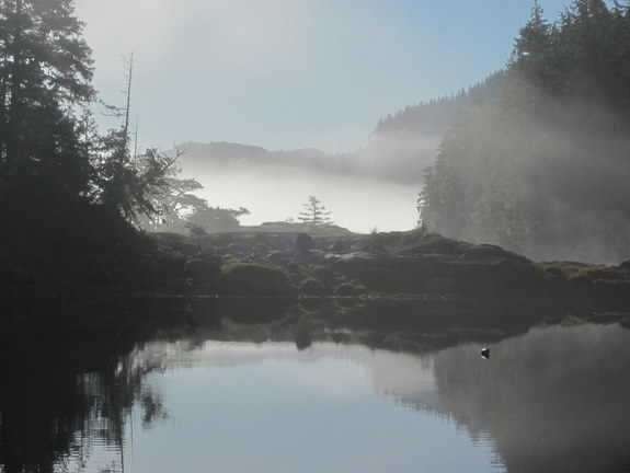
The Pacific Northwest is fantastic cruising grounds. Many people say this, but prior to spending 6 weeks cruising the south coast of British Columbia, I didn’t really understand what they meant. Here’s my version of what it’s like to be on a sailboat in these protected waters during late August, September and early October.
Pros
– Wilderness cruising – after you start through Johnstone Strait, you are surrounded by tree-lined shores, undeveloped islands and snow covered peaks. If you enjoy getting away from civilization, then this is the right place. Be prepared to be self-sufficient. Cell phone signals are scarce. SSB radios are useful for cruisers nets, downloading weather forecasts and staying in contact with those you love.
– Vast protected cruising grounds spanning many hundreds of miles – spending 6 weeks doing over 800 nautical miles (return) was only scratching the surface. We made it as far as the Broughtons, and spent a day sailing in Queen Charlotte Strait. So we did not make it to the NW tip of Vancouver island, and we weren’t even half way to the Alaskan border. This is a huge area to explore by boat, and you’ll want a kayak to investigate these protected waters closer. This area deserves time and on occasion Mother Nature will demand that you give it that deserved time – which means the tidal currents and weather will dictate many of your movements, not your pre-planned vacation schedule.
– Multitudes of excellent anchorages – it’s easy to find a secure anchorage every night. Many of them are well-protected coves surrounded by nature with no recent sign of humans. In the off-season, you will be the only boat there. If you prefer marinas, there are some around and they each strive to make you feel welcome. Do your research before leaving, though – you may find the marina or other facility closed when you get there, despite what the guidebook says. There is just not a long enough season to make a marina/supply store be a stable business. July and August are the only months they are “busy” (which is not the same kind of “busy” you experience in city life.)
– Abundance of marine wildlife – whales, dolphins, birds, fish. It’s fantastic when the Dahl porpoises came play in your wake. This is cruising in nature and it’s lovely.
– Ample guidebooks and reliable charts are available to explain the area in great detail. We had several guidebooks, but heavily relied on Exploring the South Coast of British Columbia by Don Douglass and Reanne Hemingway Douglass.
Cons
– Fickle wind – it is too frequently absent. You must be willing to motor all day, maybe for many days in a row. When its sunny and warm, in general there is no wind – but you cannot count on this as sometimes onshore flow creates gale force winds that is funneled by the narrow channels that make up the inside passage. When a frontal system passes, then there is wind – and perhaps a lot of it. If you are a fair weather sailor without a reliable auxiliary motor that you can tolerate, you don’t want to cruise in this area.
– Cold weather and rain happens too often any time of year, causing severe moisture problems aboard. It’s typically a slow all day rain with heavy grey skies. Onboard, everything gets damp. Areas that are not insulated will be dripping with condensation. You must be prepared for this bone-chilling wetness, even if you hide all day in the cabin. Cotton fabric is your enemy when it gets so damp.
– Cold water (around 10C or 50F) means cold breezes and you must not go overboard. If there is any wind at all, I’m covered head to foot to protect myself from the cold air. All those photos of bikini-clad beautiful women lounging on sailboats were not taken in this area!
So what’s the best boat for cruising this area? Many people will tell you “this is powerboat country” but I actually think a motorsailer like our Nicholson 38 is the right boat. Here’s what you need on your boat to enjoy this area:
– Cockpit protection from the cold wind, and the rain when it happens. We have a fully enclosed center cockpit, and it’s wonderful. I couldn’t imagine being in an aft cockpit without a proper dodger. Oh, and add a windscreen wiper if you are bothered by water beaded on your windscreen. There are a lot of grey misty days…
– Cabin heater that provides dry heat to warm you up in the morning or after a day underway, even in the summer months. On land it may be hot, but on the water, the nights are cold. Though we were cruising during a September “heat wave”, we used our Webasto forced air diesel heater nearly every day. Don’t try to heat directly with propane or other wet source of heat – you need to get the cabin air dried out as best as possible.
– Insulation on the hull, or the condensation will turn your cabin interior black with mildew in a matter of days. We reached >90% humidity in the cabin on many days after cooking. That’s miserable when the cabin air is cool. And figure out how to make a dry berth, because it’s rough sleeping in damp cotton sheets on a moldy smelling foam cushion.
– Good motor, and you must be willing to use it – for days on end. Sometimes you’ll forget you’re in a sailboat. It’s really that bad. I am willing to sail in the lightest of airs – 5 knots will do, and yet we spent days without unfurling the sails at all. It’s sad really, and annoying to be surrounded by such lovely natural scenery with a diesel motor polluting it all.
– Light air sails, for those times when there is a slight breeze and you are desperate to shut off the growling motor beast that’s invaded your peaceful sailing vessel.
– Heavy-weather capable boat, because it will get rough. This is why I think it’s not really powerboat country. The right sailboat can handle wind and waves much better than a powerboat. To reach the protected waters, you need to cross big open water (Strait of Georgia, which is where we experienced 20-30 knot winds and 2 meter waves) and make your way up some notoriously rough and windy channels (Johnstone Strait). I’d rather do that in a sailboat than a power boat (though I must admit I’ve never been in a powerboat, so I’m making that statement based on hearsay.)
– Good ground tackle, including at least 100 meters of line for stern tying when the anchorage doesn’t have sufficient swing room (200 meters would be better). It’s nice to stern tie anyway, to stop the boat from swinging. We spent many a night listening to our all chain rode scrape across rocks as the boat swung on its anchor due to currents or winds. We were able to get our Manson Supreme anchor set well and it held every night, despite the fact that some of the heavy weather brought 25 knot gusts into our “protected” anchorage.
– Radar for being underway in the fog. We had fog only a few days, but that’s because we got lucky. Reportedly, the fog can last for days.
– GPS/Chartplotter to know your location. This area is littered with places to run aground, and there are so many little islands it’s easy to get lost – especially in the Broughtons when its foggy. Also, buy proper Canadian Hydrographic Service (CHS) paper charts before you go – the idea of buying charts enroute doesn’t work very well, as most the chart suppliers we visited had a very limited stock. If you buy the CHS #3312 and #3313 chart books for recreational boaters, look carefully at what areas are not covered in sufficient detail by those books – for example, you still need the Sunshine coast strip chart #3311, Baynes Sound #3527, Nanoose Harbour #3459 and maybe Campbell River #3450, even though most these areas are ostensibly covered by the chart books. Get the free CHS Pacific Coast atlas and study which charts you need before you go. Get each that you think you might need, including #3564 if you plan to go up Chatham Channel or visit Port Harvey.
– Tide and Current books – the channels are described as saltwater rivers, and some of them can flow up to 16 knots during spring tide. You must be able to time your arrival for slack water in many areas, and this means you must have accurate tidal and current information. Be aware that the Canadian Hydrographic Service timetables are NOT correct for daylight savings time. I also found the distance tables and other reference information in Local Knowledge: A Skipper’s Reference by Kevin Monahan to be valuable during the hours I spent each night determining our options for the next day.
In short, I think our Nicholson 38 is the perfect boat for this area. 8~) That is, after we solve the condensation problems and improve the berth. We got pretty soggy at times. The Webasto heater we installed earlier this year was greatly appreciated.
These cruising grounds are broken into distinct areas. I’ll give accounts and photos about each of the areas we visited in other postings, including:
Strait of Georgia and the Sunshine Coast
Inside Passage (Johnstone Strait)
Broughtons and Tribune Channel
-
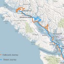
- We travelled about 850 miles through the water according to the log. Since we generally travel with current helping us, we travelled further “over ground” – but I have no idea how much further.
-
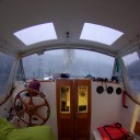
- When the weather turns cold and wet, it’s lovely to have a fully enclosed center cockpit.